Ihr Warenkorb ist leer
Deutsch


Für eine relativ kleine Insel übertrifft Großbritannien sein Gewicht, wenn es um die geologische Vielfalt geht. Unsere Landschaft ist ein 3-Milliarden-Jahre-Archiv der Erdgeschichte, komprimiert auf nur 94.000 Quadratmeilen. Diese außergewöhnliche Vielfalt ist auf die stürmische geologische Vergangenheit Großbritanniens zurückzuführen. Unsere Gesteine wurden durch extreme Hitze und Druck umgewandelt, durch kollidierende Kontinente in die Höhe geschoben, von tropischen Meeren überflutet und von kilometerdicken Eisschilden freigekratzt.
Vor etwa 500 Millionen Jahren lag das Gestein, aus dem später Schottland wurde, in der Nähe der Antarktis, während England sich in der Wärme des Äquators sonnte. Die Kontinentalverschiebung brachte diese Fragmente zusammen und schuf eine geologische Verwerfungslinie, die noch heute in den schottischen Borders sichtbar ist. Später wurde Großbritannien von flachen tropischen Meeren überflutet, die den Karbon-Kalkstein ablagerten, der heute das Rückgrat der Pennines und das Grundgestein von Yorkshire bildet.
Die Eiszeit, die vor etwa 11 700 Jahren endete, war der letzte Bildhauer der modernen Landschaft Großbritanniens. Gletscher gruben tiefe Täler, transportierten Felsbrocken Hunderte von Kilometern von ihrem Ursprung weg und kratzten Kalksteinpflaster in die verschlungenen Muster, die wir heute sehen. Zwischen den Gletschervorstößen war Großbritannien abwechselnd mit Kontinentaleuropa verbunden und von ihm abgetrennt, wodurch die Insel entstand, die wir heute bewohnen.
Und das Ergebnis? Wir haben alles, vom 3 Milliarden Jahre alten Lewis-Gneis an der schottischen Westküste, der zu den ältesten Gesteinen der Welt gehört, bis hin zu Kreidefelsen, die vor etwa 100 Millionen Jahren aus unzähligen Meeresorganismen entstanden sind. Im Dartmoor gibt es Granittürme, die zu unwahrscheinlichen Stapeln verwittert sind, Old Red Sandstone, der in den Brecon Beacons in Falten gelegt wurde, und Basaltsäulen am Giant's Causeway, die vor 60 Millionen Jahren aus vulkanischer Lava erkalteten.
Ein Spaziergang durch Großbritannien ist wie eine Zeitreise durch geologische Epochen. Hier sind einige der spektakulärsten und merkwürdigsten Felsformationen, die unsere Insel zu bieten hat.

Beim Aufstieg zum Gipfel des Ingleborough trifft man auf eine außergewöhnliche, weitläufige Landschaft an der Westflanke des Berges. Während der letzten Eiszeit schabten gewaltige Gletscher den Oberflächenboden ab und legten den darunter liegenden Kalkstein frei. Seitdem haben jahrtausendelange säurehaltige Regenfälle komplizierte Muster in das weiche, alkalische Gestein geätzt und schmale Spalten, so genannte Grykes, geschaffen. Diese Miniatur-Canyons - eine felsige Version der Oberfläche des Todessterns - beherbergen heute Boden- und Waldpflanzen und schaffen unerwartete grüne Flecken inmitten des grauen Steins.
Von Ingleton aus gehen Sie auf der High Street nach Osten, bevor Sie rechts auf den Fell Lane Footpath (Teil des Pennine Journey) abbiegen. Folgen Sie dem Weg für 1½ Meilen und nehmen Sie kurz vor dem Bauernhof den Pfad links zum Gipfel.

Unweit des verschlafenen Dorfes Beetham befinden sich in einem schmalen Spalt zwischen Kalksteinklippen Steinstufen, die vor Jahrhunderten gehauen wurden. Diese als "Fairy Steps" bekannte Treppe war Teil einer "Geisterstraße" - der einzige Weg zu einem geweihten Platz für lokale Beerdigungen. Die Trauernden mussten ihre Särge durch den engen Durchgang manövrieren, ebenso wie andere, die von Arnside zur Kirche von Beetham unterwegs waren. Die Legende besagt, dass jedem, der sich zwischen den Felsen hindurchzwängt, ohne sie zu berühren, von den Feen ein Wunsch erfüllt wird. Der Spaziergang kann durch den Wildpark südwestlich von Milnthorpe verlängert werden und führt in einer Schleife über die Küste und zurück durch die westlichen Wälder von Beetham.
Parken Sie am Pub in Beetham (eine gute Ausrede für ein Pint und ein Pub-Mittagessen nach Ihrer Wanderung). Gehen Sie die Straße zwischen der Kirche und dem Pub hinunter, vorbei am alten Postamt. Biegen Sie links ab und gehen Sie über einen Steinpfosten auf ein Feld, das Sie geradeaus überqueren. Bleiben Sie im Wald auf dem Weg, bis Sie eine T-Kreuzung erreichen, und biegen Sie dann links ab. Gehen Sie geradeaus bis zu einem festen Steinhaufen, der die Fairy Steps markiert.

Hoch in den Hügeln von Lancashire liegen ungewöhnlich hohe Felsblöcke, die von schmelzenden Gletschern abgelagert wurden. Die Norber Erratics bestehen aus Grauwacke, einem uralten, außergewöhnlich harten Gestein, das einst von ägyptischen Bildhauern wegen seiner Widerstandsfähigkeit gegen Risse geschätzt wurde. Diese Beständigkeit hat nicht nur die Felsen selbst, sondern auch den weichen Kalkstein unter ihnen geschützt. Im Laufe der Jahrtausende ist der umgebende Kalkstein erodiert, während das Gestein unter den Findlingen intakt blieb, so dass die älteren Felsen wie geologische Skulpturen auf Kalksteinsockeln thronen. Die Erratics sind Teil der anspruchsvollen 247 Meilen langen Pennine Journey-Rundwanderung.
Vom Parkplatz in Ingleborough aus gehen Sie in Richtung Norden, bevor Sie dem markierten Pennine Journey-Fernwanderweg in Richtung Osten folgen. Nach etwa 30 Minuten nehmen Sie den Fußweg rechts zu den Erratics.

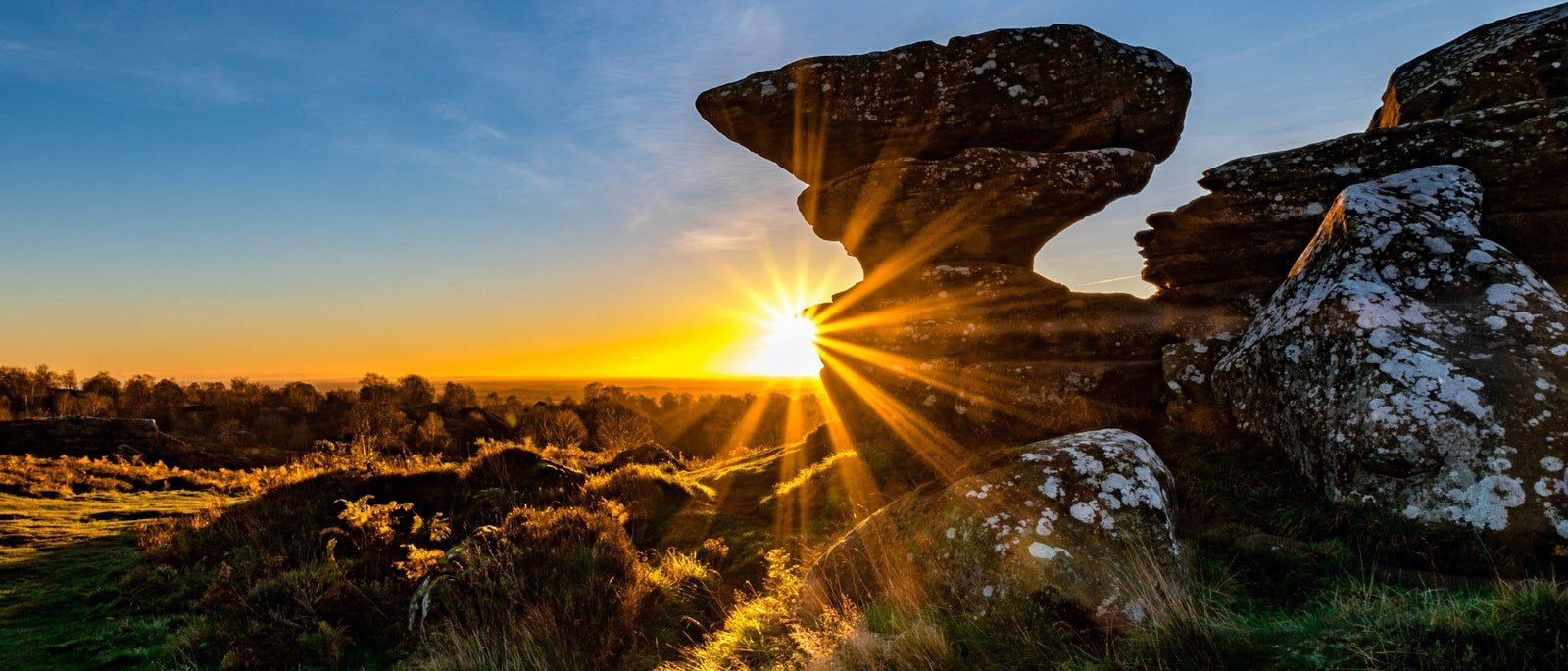
Vor etwa 320 Millionen Jahren, lange vor der Entwicklung der Dinosaurier, sammelte sich Sand auf dem Grund eines flachen Meeres, das dieses Land bedeckte. Unter enormem Druck verdichtete sich dieser Sand zu Gestein. Kontinentalkollisionen drückten den Meeresboden später in die Höhe. Gletscher schabten dann durch die angehobene Landschaft, und Millionen von Jahren mit Frost-Tau-Zyklen, Regen und Wind begannen, die Felsen abzutragen. Da das Gestein in Stärke und Dicke variierte, schuf die Verwitterung die heute sichtbaren fantastischen Formen. Ohne modernes geologisches Wissen schrieben die georgischen und viktorianischen Besucher diese Formationen einer biblischen "großen Flut" zu.
Brimham gehört zum National Trust und ist von Ripon aus mit dem Auto zu erreichen. Folgen Sie der Westgate nach Westen auf die Park Street, fahren Sie geradeaus über zwei Kreisverkehre und biegen Sie auf die B6265 (Studley Road) ein. Nach etwa 6½ Meilen folgen Sie den Schildern des National Trust zum Parkplatz.

Ein Blick in diese 24 Meter tiefen Kalksteinspalten ist ausgesprochen beunruhigend. Im Laufe der Jahrtausende sickerte saures Regenwasser in die Risse des weichen Karbon-Kalksteins, wodurch die schwächeren Schichten erodierten und immer tiefere Klüfte entstanden. Der Ursprung des Namens ist ungewiss, aber einige Historiker vermuten, dass Markthändler während der Sommermonate Butter in die kühlen Tiefen hinabgelassen haben könnten. Die Temperatur in diesen natürlichen Kühlschränken hätte verhindert, dass die Butter in der Hitze verdirbt.
Starten Sie am Green Dragon in Hardraw, bevor Sie die vier Meilen lange Strecke zu den Buttertubs mit dem Fahrrad, zu Fuß oder mit dem Auto zurücklegen. Nehmen Sie Bellow Hill East und biegen Sie dann links ab und folgen Sie den Schildern nach Simonstone und Muker (über Buttertubs). Fahren Sie weiter, bis Sie bei den Koordinaten 54.36005, -2.1952 ankommen. Die Buttertubs erscheinen auf beiden Seiten der Straße.

Porth Nanven ist ein wunderbar exzentrischer Ort, den man über eine gewundene Straße erreicht, auf der subtropische Pflanzen gedeihen und Emus und Lamas auf den nahe gelegenen Feldern grasen. Der Strand selbst ist mit Hunderten von abgerundeten Felsbrocken übersät, die an Dinosauriereier erinnern, obwohl diese Steine eine andere prähistorische Geschichte erzählen. Vor etwa 120.000 Jahren, als der Meeresspiegel viel höher war, standen diese Klippen unter Wasser. Die Wellen schliffen die Felsen in turbulenten Stürmen ab und lagerten sie an der Stelle ab, an der die Klippen entstanden. Im Laufe der Jahrtausende verdichteten sie sich zu dem erhöhten Strand des Kliffs. Heute gibt die Erosion die alten Felsbrocken auf den modernen Strand darunter frei und schafft so dieses bemerkenswerte geologische Schauspiel.
Obwohl es am Strand Parkplätze gibt, ist der Zugangsweg ein schmaler Feldweg, so dass man besser zu Fuß oder mit dem Fahrrad unterwegs ist. Von St. Just aus erreichen Sie den Lafrowda-Parkplatz, biegen links ab (gegenüber der Bibliothek), dann an der Kreuzung rechts und schließlich links an der Schule vorbei. Bleiben Sie auf diesem Weg bis zur Küste.

Diese musikalische Kuriosität liegt versteckt in der Nähe einer kleinen Steinbrücke in den Cairngorms, an der Old Military Road, die durch den Park führt. Wenn man mit einem Hammer oder Stein darauf schlägt, läutet diese kieselsäurereiche Granitplatte wie eine Kirchenglocke. Die Beschaffenheit des Steins und seine erhöhte Lage - vom Boden abgehoben und mit einem Hohlraum darunter - tragen wahrscheinlich zu seinen akustischen Eigenschaften bei. Diese natürlich vorkommenden Lithophone gibt es weltweit, von Westaustralien bis Pennsylvania. In der näheren Umgebung finden Sie auch eines auf Tiree sowie ein Steinxylophon im Keswick Museum im Lake District.
Von der Gairnshiel Lodge aus gehen Sie auf der Old Military Road etwas mehr als eine halbe Meile nach Norden. Achten Sie auf eine Steinbrücke an einer Parallelstraße auf der linken Seite. Ein Pfad führt zu dem Stein auf einem kleinen, mit Farnkraut bewachsenen Hügel vor der Brücke. Verwenden Sie eine Kartensoftware, um zu den Koordinaten 57.0997, -3.1573 zu navigieren und den genauen Standort zu bestimmen.

Vor Millionen von Jahren war die Isle of Wight Teil eines riesigen Gezeitenmündungsgebiets, in dem verschiedene Dinosaurierarten an schlammigen Flussufern lebten. Die Kombination aus einer Vielzahl von Dinosauriern und dem konservierenden Mündungsschlamm macht die Isle of Wight zu einem der besten Standorte für Dinosaurier-Fußabdrücke in Großbritannien. Am Hanover Point (östlich des Parkplatzes) finden Sie Abdrücke von Sauropoden - riesigen pflanzenfressenden Dinosauriern mit runden Füßen. In Compton Bay finden Sie wunderschön erhaltene Abdrücke von kleinen Theropoden, der Gruppe, zu der auch Tyrannosaurus Rex und Velociraptoren gehörten.
Begeben Sie sich zum National Trust Car Park in Compton Bay, PO30 4HB. Gehen Sie hinunter zum Strand und biegen Sie links ab. Die Abdrücke sind am besten bei Ebbe zu sehen.
Alle Bilder über Adobe Stock.
 |
 |